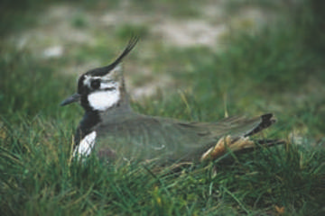
Lapwing © Simon Booth
The Lapwing has been widely publicised as one of the birds that has declined as a result of agricultural changes, and is Amber Listed as a result, so the maps for this species have been eagerly awaited. As it happens, breeding Lapwings are probably more widespread than many had feared, being still found in 72% of the county’s tetrads. This is one of the species that makes a good case for undertaking surveys at a finer scale than the national Atlases. Although Lapwing has shown a large population decline, their distribution has not noticeably contracted at the 10-km square scale, indicating that they remain widespread but at lower density (Fuller et al 1995). Comparing with our First Atlas, they were found in 438 tetrads in both surveys, and have been gained in 45, mostly in a band running north-south through the southern part of Cheshire, but these are outnumbered by the 127 losses, scattered widely across the county. The most obvious factor determining their distribution in this Atlas was their avoidance of urban areas. All of the county’s conurbations show up as gaps on the map: east Wirral, Heswall, Ellesmere Port, Chester, Runcorn and Widnes, Warrington, Northwich, Macclesfield, Congleton, Sandbach, Nantwich and Crewe. It seems that they are happy to breed on suitable rough land in industrial areas, such as Birkenhead Docks and the Stanlow petrochemical complex, but not amidst human dwellings.
The habitat codes show that Lapwing is overwhelmingly a farmland bird, with 84% of the records, especially on tilled land (25% of the total): this is more than twice as many records on tilled land as any other species in this Atlas. Others were on improved grassland (24%), mixed grassland/ tilled land (21%) and unimproved grassland (9%). Some birds used semi-natural grassland or marsh, mainly water-meadow/ grazing marsh (3% of records) and ‘other dry grassland’ (2%), and 5% were recorded alongside waterbodies, including sandquarries.
The national population was stable until 1984, coincidentally the last year of our First Atlas fieldwork, then dropped by one half in just ten years, and has now levelled out since then. National surveys in England and Wales showed a 49% population decline between 1987 and 1998, and a 60% fall in northwest England (Wilson et al 2001). The reasons for the decline have been intensively studied. The key factor is that their productivity is too low, with too few chicks surviving to balance adult mortality. Lapwings nest from early April to late June or even July, and some will lay up to three or four times in attempts to raise a brood, but are succeeding far less often these days. On agricultural land, many nests fail owing to predation, mainly by nocturnal mammals. Nests within 50 m of a field boundary have only about half of the chance of survival of those farther away from the edge (Sheldon et al 2007). Although they favour tilled land, as shown by the habitat preferences in this Atlas, they prefer spring-sown crops, especially when adjacent to permanent grassland (Wilson et al 2001); Lapwings often nest in one type of habitat and lead their young chicks, some distance if necessary, to a different type that offers more soil invertebrates. With increasingly specialised modern agriculture, such mixtures of habitats are not often found.
The analysis of Breeding Bird Survey transects shows that the breeding population of Cheshire and Wirral in 2004-05 was 7,980 birds (1,310-14,650). This amounts to 2.5% of the UK total, so the number of Lapwings in the county is quite significant in national terms.
Contrary to the decline on lowland farmland, surveys of the South Pennines Moors SPA, of which the Cheshire moors are a part, showed an 80% rise between 1990 and 2004-05 in the breeding population of Lapwings (Eaton et al 2007).
Sponsored by Chris Honer

