About the area - Cheshire and Wirral and its habitats for birds
Situated in the northwest of England, Cheshire and Wirral spans 84 km (52 miles) from east to west and 58 km (36 miles) from north to south, a land area of about 2,498 km2, which happens to be about 1% of the area of the UK (244,820 km2). The human population, at the 2001 census, was almost 1.3 million.

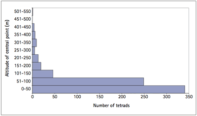
Tetrads by median altitude.
Administratively, English counties have undergone substantial changes in the last 35 years. The boundaries for ornithological recording of Cheshire and Wirral were agreed and set in 1978, following the major revision of local authorities in 1974, which included creation of the Metropolitan Borough of Wirral. Halton and Warrington were formed as Unitary Authorities in 1998, and the remainder of Cheshire is to be split into two new Unitary Authorities, Cheshire East and Cheshire West and Chester, from 2009.
Despite these changes in local authorities, thankfully, ‘ornithological Cheshire and Wirral’ has remained the same since our First Atlas.
It is not just the boundaries that have undergone extensive modification by man. As with most of England, there is little or no ‘natural’ habitat left in Cheshire and Wirral. Broadly speaking, the county has an agricultural southwest, urban and industrialised north, and heavily grazed higher land in the east. According to the most recently available land-use statistics, from the year 2000 (Haines-Young et al 2002), 72% of the land area of Cheshire and Wirral is grassland or arable, 8% woodland and 16% developed, with the remainder estuarine and coastal (3%), inland freshwater (0.7%) and heath or bog (0.5%).
The underlying geology consists mainly of Triassic sandstones, with the eastern hills of Millstone Grit. The hill country, roughly east of Macclesfield and Congleton, is mostly Carboniferous grits and shales, cut by several steep rivers, and is mainly farmed as unimproved grassland. The high plateau in the far east of Cheshire consists mostly of grassland, cotton-grass or heather moorland. Elsewhere in the county the only high land is where the red Bunter sandstone forms outcrops, such as the Sandstone Ridge from Bickerton to Helsby and Frodsham Hills; other lines of ridges define the Wirral, with obvious outcrops at Red Rocks and Hilbre. Most of Cheshire and Wirral is low-lying, however, with 85% of tetrads within 100 m of sea level.
Flooding of the Cheshire Plain 220 million years ago laid down large beds of minerals in the centre of the county, now being worked for the nationally important resources of salt and silica sand. Natural dissolution of the salt probably led to formation of some of the county’s meres, and the subsidence of old salt excavations caused the flashes. In agricultural terms, the parts of the Plain overlain with Boulder clay, mainly to the south and west, have mostly been farmed as improved grassland; a notable feature is the many thousands of ‘marl pits’, ponds formed about two centuries ago where slightly calcareous subsoil was dug out to fertilise farmland, helping the county to its position as the pond capital of Europe. The better-drained areas to the north and mid-west of the county have proved suitable for arable cropping, while the very sandy soils across the centre of the county, from Delamere to Congleton, have been difficult to farm and are dominated by forestry plantations or sand quarries. The areas of the highest grade of agricultural land are mainly where former mosses have been destroyed by drainage, especially along the Mersey valley and parts of the ‘Meres and Mosses country’ of central southern Cheshire.
The remainder of this chapter presents some statistics, maps and images of some, but by no means all, of Cheshire and Wirral’s habitats for birds.
The habitat distribution maps are compiled from the CEH 'landcover 2000' data (Haines-Young et al. 2002); the key at the bottom left of each map indicates, using square symbols of decreasing size, the proportion of this type of habitat in each 1 × 1 km square.

